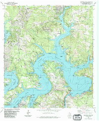
1986 Map of Mansfield Dam
USGS Topo · Published 1986About this map
Mansfield Dam and its adjacent Powerplant anchor this 1986 survey of the twisting waterways of Lake Travis and the upper reaches of Lake Austin. The map details the mid-1980s expansion of the Austin Corporate Boundary into the surrounding hills and peninsulas, where planned developments like Lago Vista and Lakeway intersect with older rural landmarks. Genealogists will find notable sites such as Simpson Cem near Arkansas Bend and the Teck Cem located inland from Graveyard Point. The topography is defined by deep incisions like Pool Canyon and Devils Hollow that feed into the major reservoir arms. Historical transportation routes, including Boggy Ford Road and Lohmans Crossing Road, connect the established settlements of Jonestown and Volente, illustrating the suburban transition of the Texas Hill Country during this era.
Find a feature on this map
63 named features on this map. Tap any name to fly to it.
Don’t see what you’re looking for? This feature index may not catch every label — zoom into the map to look around manually.
Map Details
Editions of this 1986 Mansfield Dam Map
This is the sole edition of this map. No revisions or reprints were ever made.
Other maps of this area

1887 · Blanco
USGS Topo · 1:125,000

1887 · Burnet
USGS Topo · 1:125,000

1893 · Georgetown
USGS Topo · 1:125,000

1893 · Burnet
USGS Topo · 1:125,000

1894 · Blanco
USGS Topo · 1:125,000

1896 · Austin
USGS Topo · 1:125,000

1897 · Austin
USGS Topo · 1:125,000

1903 · Burnet
USGS Topo · 1:125,000

1909 · Burnet
USGS Topo · 1:125,000

1910 · Austin
USGS Topo · 1:125,000