1963 Map of Manuelito
USGS Topo · Published 1980About this map
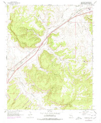
The Atchison Topeka and Santa Fe railroad corridor and the Puerco River dominate this western New Mexico landscape, following a natural travel path through a region of deep drainage and high mesas. The 1963 survey, updated with 1979 revisions, highlights the small settlements of Manuelito and Defiance along the rail line, showing how transportation infrastructure dictated the location of human activity in McKinley County. Significant terrain features such as Torrivio Mesa and Purty Rock are clearly delineated alongside numerous named canyons, including Manuelito Canyon and Eagles Nest Canyon. The map records essential water sources in this arid environment, specifically Sand Spring and Salt Water Wash. This revision also tracks the development of the modern highway system, marking both 66 and 40 as they parallel the older rail and river routes.
Find a feature on this map
31 named features on this map. Tap any name to fly to it.
Don’t see what you’re looking for? This feature index may not catch every label — zoom into the map to look around manually.
Map Details
Editions of this 1963 Manuelito Map
2 editions found
Other maps of this area

1886 · Wingate
USGS Topo · 1:250,000

1886 · Fort Defiance
USGS Topo · 1:250,000

1892 · Fort Defiance
USGS Topo · 1:250,000

1892 · Wingate
USGS Topo · 1:250,000

1954 · Gallup
USGS Topo · 1:250,000

1958 · Gallup
USGS Topo · 1:250,000

1959 · Gallup
USGS Topo · 1:250,000

1962 · Gallup
USGS Topo · 1:250,000
1963 · Twin Buttes
USGS Topo · 1:24,000
1963 · Gallup West
USGS Topo · 1:24,000
Featured Places
- Eastern Navajo Agency, NM
- Manuelito, Eastern Navajo Agency
- Defiance, NM
- McKinley County, NM
- United States