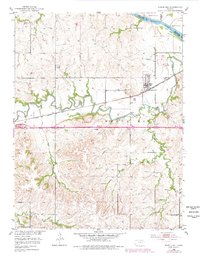
1953 Map of Maple Hill
USGS Topo · Published 1978About this map
Mill Creek meanders sharply through the center of this landscape, its tight oxbows defining the geography between the small settlements of Maple Hill and Vera. This mid-century survey illustrates the corridor where the Chicago Rock Island and Pacific railroad parallels the creek, a traditional transport artery contrasted by the addition of Interstate 70 cutting west across the quadrangle. To the north, the Kansas River forms a natural border with Shawnee County, while the terrain is punctuated by landmarks such as Buffalo Mound and the Maple Hill Ch. Local industry and infrastructure are noted through a Mine near Turkey Creek and a Radio Tower further south. The map reflects a rural Kansas township in transition, maintaining its agricultural and river-valley roots while adapting to modern high-speed transit.
Find a feature on this map
18 named features on this map. Tap any name to fly to it.
Don’t see what you’re looking for? This feature index may not catch every label — zoom into the map to look around manually.
Map Details
Editions of this 1953 Maple Hill Map
2 editions found

Other maps of this area

1885 · Eskridge
USGS Topo · 1:125,000

1889 · Burlingame
USGS Topo · 1:125,000

1889 · Wamego
USGS Topo · 1:125,000

1889 · Eskridge
USGS Topo · 1:125,000

1889 · Topeka
USGS Topo · 1:125,000

1894 · Eskridge
USGS Topo · 1:125,000

1894 · Burlingame
USGS Topo · 1:125,000

1894 · Topeka
USGS Topo · 1:125,000

1894 · Wamego
USGS Topo · 1:125,000

1947 · Lawrence
USGS Topo · 1:250,000