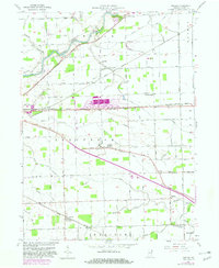
1957 Map of Maples
USGS Topo · Published 1982About this map
The Maumee River corridor and the flat agricultural lands of Allen County define this landscape, where a dense network of drainage ditches—including the Marsh Ditch and Grover Ditch—reflects the intensive engineering required to transform the former Great Black Swamp into productive farmland. The settlement of Maples serves as a local hub along the Conrail line, while the Lincoln Highway cuts a distinctive diagonal across the center of the sheet, linking Tillman and Zulu. Educational and spiritual life is anchored by landmarks like the St Louis Academy, Peoples Chapel, and the St Pauls Ch, alongside rural cemeteries such as Gar Creek Cem. A significant industrial or rail facility is noted in purple near Edgerton, appearing as a later revision to the original mid-century topography. From the New Haven Conservation Club in the northwest to Four Presidents Corners in the southeast, the map documents the persistent grid of farm roads and the legacy of early Indiana transit routes.
Find a feature on this map
73 named features on this map. Tap any name to fly to it.
Don’t see what you’re looking for? This feature index may not catch every label — zoom into the map to look around manually.
Map Details
Editions of this 1957 Maples Map
3 editions found
Other maps of this area

1953 · Fort Wayne
USGS Topo · 1:250,000

1953 · Muncie
USGS Topo · 1:250,000

1956 · Muncie
USGS Topo · 1:250,000

1956 · Fort Wayne
USGS Topo · 1:250,000

1956 · Fort Wayne East
USGS Topo · 1:24,000

1956 · Cedarville
USGS Topo · 1:24,000

1957 · Maples
USGS Topo · 1:24,000

1958 · Grabill
USGS Topo · 1:24,000

1958 · Woodburn North
USGS Topo · 1:24,000

1958 · Woodburn South
USGS Topo · 1:24,000