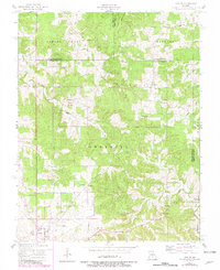
1954 Map of Maples
USGS Topo · Published 1980About this map
Maples sits at the intersection of Texas, Phelps, and Dent counties, serving as a quiet focal point for this rural Missouri landscape. The terrain is deeply carved by the headwaters of the Current River and Sherrill Creek, creating a network of ridges where early 20th-century life centered around small country schools and churches. Family-named landmarks such as Hutchison Cem and Williams Cem provide essential data points for genealogical research, while institutions like Crow School and Stoney Point School reflect the distributed settlement pattern of the era. The southern portion of the map transitions toward Licking, showing the early road networks and rural properties that defined the region before modern highway expansions. This survey, photorevised in the early 1980s based on mid-century topography, documents the persistence of places like Kimble and Coulstone amidst the Ozark foothills.
Find a feature on this map
32 named features on this map. Tap any name to fly to it.
Don’t see what you’re looking for? This feature index may not catch every label — zoom into the map to look around manually.
Map Details
Editions of this 1954 Maples Map
2 editions found
Other maps of this area

1932 · Cedar Grove
USGS Topo · 1:48,000

1937 · Edgar Springs
USGS Topo · 1:48,000

1941 · Salem
USGS Topo · 1:62,500

1945 · Salem
USGS Topo · 1:62,500

1945 · Edgar Springs
USGS Topo · 1:62,500

1949 · Rolla
USGS Topo · 1:250,000

1951 · Montauk
USGS Topo · 1:24,000

1951 · Licking
USGS Topo · 1:24,000

1951 · Prescott
USGS Topo · 1:24,000

1951 · Raymondville
USGS Topo · 1:62,500