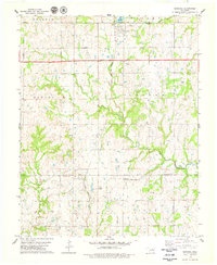
1978 Map of Maramec
USGS Topo · Published 1979About this map
The town of Maramec and the community of Quay anchor this late-1970s landscape, where the agricultural sections of the Burnham and Banner townships are heavily overlaid with energy infrastructure. The map reveals an extensive Oil Field and the more localized Oil Lagoon Field, characterized by numerous individual oil wells scattered across the terrain. This industrial development exists alongside a transit network including the Cimarron Turnpike and the tracks of the Atchison Topeka and Santa Fe and Missouri-Kansas-Texas railroads.
Find a feature on this map
26 named features on this map. Tap any name to fly to it.
Don’t see what you’re looking for? This feature index may not catch every label — zoom into the map to look around manually.
Map Details
Editions of this 1978 Maramec Map
This is the sole edition of this map. No revisions or reprints were ever made.
Other maps of this area

1929 · Yale
USGS Topo · 1:62,500

1929 · Ripley
USGS Topo · 1:62,500

1929 · Skedee
USGS Topo · 1:62,500

1930 · Pawnee
USGS Topo · 1:62,500

1931 · Skedee
USGS Topo · 1:62,500

1932 · Yale
USGS Topo · 1:62,500

1932 · Ripley
USGS Topo · 1:62,500

1936 · Pawnee
USGS Topo · 1:62,500

1955 · Enid
USGS Topo · 1:250,000

1958 · Enid
USGS Topo · 1:250,000