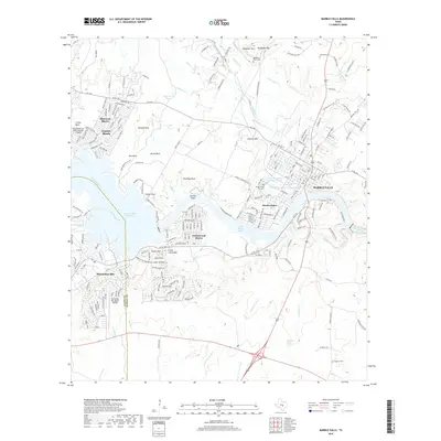
2019 Map of Marble Falls
USGS Topo · Published 2019About this map
Marble Falls and its surrounding Hill Country landscape are defined by the winding course of the Colorado River, which broadens into Lake Lyndon B Johnson and Lake Marble Falls. This 2019 survey documents a region characterized by significant residential growth and aviation infrastructure, including the Horseshoe Bay Resort Airport and the Granite Shoals/Bob Sylvester Airpark. The area's geology is prominently featured through massive outcroppings like Granite Mtn, Castle Mtn, and named formations such as Goose Rock and Kennison Rock. Established communities like Meadowlakes, Cottonwood Shores, and Sherwood Shores line the waterfront, while the northern reaches of the quadrangle transition into higher elevations marked by Slaughter Mtn and Slaughter Gap. Genealogists and local historians can locate several rural burial sites, including the Slaughter Ranch Cem and the Konvicka Cem, which sit near the northern boundary of Burnet Co.
Find a feature on this map
58 named features on this map. Tap any name to fly to it.
Don’t see what you’re looking for? This feature index may not catch every label — zoom into the map to look around manually.
Map Details
Editions of this 2019 Marble Falls Map
This is the sole edition of this map. No revisions or reprints were ever made.
Other maps of this area

1887 · Blanco
USGS Topo · 1:125,000

1887 · Burnet
USGS Topo · 1:125,000

1893 · Burnet
USGS Topo · 1:125,000

1894 · Blanco
USGS Topo · 1:125,000

1903 · Burnet
USGS Topo · 1:125,000

1909 · Burnet
USGS Topo · 1:125,000

1925 · Burnet 3-b
USGS Topo · 1:48,000

1925 · Burnet 3-d
USGS Topo · 1:48,000

1929 · Marble Falls
USGS Topo · 1:62,500

1931 · Marble Falls
USGS Topo · 1:48,000