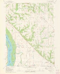
1971 Map of Marblehead
USGS Topo · Published 1973About this map
The eastern banks of the Mississippi River dominate this landscape, characterized by a complex network of wetlands and islands like Whitney Island and Mc Donald Island. The engineering of the riverbank is evident through the massive levee system and water management features such as the Austin Creek Settling Basin and the Fall Creek Settling Basin. Settlement patterns follow the higher ground above the floodplains, with small communities like Marblehead and Payson connected by the Burlington Northern railroad corridor. Genealogical interest is particularly high here, as the map records several family or local burial grounds including Craigtown Cem, Fall Creek Cem, and Thompson Cem. Near the southern edge, the Old Sny Public Use Area indicates the transition of the riparian environment into recreational space, while the presence of an Indian Mound and its namesake Indian Mound Cem points to the ancient human history of this river valley.
Find a feature on this map
52 named features on this map. Tap any name to fly to it.
Don’t see what you’re looking for? This feature index may not catch every label — zoom into the map to look around manually.
Map Details
Editions of this 1971 Marblehead Map
2 editions found
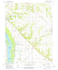
Other maps of this area

1925 · Quincy
USGS Topo · 1:62,500

1925 · Liberty
USGS Topo · 1:62,500

1927 · Liberty
USGS Topo · 1:62,500

1931 · Barry
USGS Topo · 1:62,500

1932 · Hannibal
USGS Topo · 1:62,500

1936 · Hannibal
USGS Topo · 1:48,000

1936 · Barry
USGS Topo · 1:48,000

1944 · Barry
USGS Topo · 1:62,500

1944 · Quincy
USGS Topo · 1:62,500

1945 · Hannibal
USGS Topo · 1:62,500