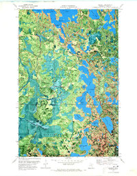
1970 Map of Marcell
USGS Topo · Published 1973About this map
Marcell sits at a nexus of water and woodland within the Chippewa National Forest, serving as a central hub for the surrounding lake country during the early 1970s. The landscape is dominated by the sprawling reaches of North Star Lake, which features prominent landmarks like Wildcat Island and a designated Campground on its eastern shore. This orthophotomap provides a rare hybrid view, combining traditional topographic contours with aerial photography that reveals the dense forest cover and the intricate shorelines of smaller bodies like Egg Lake and Little North Star Lake.
Find a feature on this map
51 named features on this map. Tap any name to fly to it.
Don’t see what you’re looking for? This feature index may not catch every label — zoom into the map to look around manually.
Map Details
Editions of this 1970 Marcell Map
This is the sole edition of this map. No revisions or reprints were ever made.
Other maps of this area

1919 · Marcell
USGS Topo · 1:62,500

1954 · Hibbing
USGS Topo · 1:250,000

1957 · Hibbing
USGS Topo · 1:250,000

1958 · Hibbing
USGS Topo · 1:250,000

1964 · Hibbing
USGS Topo · 1:250,000

1970 · Deer River NE
USGS Topo · 1:24,000

1970 · Wabana Lake
USGS Topo · 1:24,000

1970 · Clubhouse Lake
USGS Topo · 1:24,000

1970 · Jessie Lake
USGS Topo · 1:24,000

1970 · Coon Lake
USGS Topo · 1:24,000