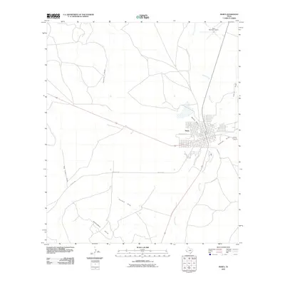
2010 Map of Marfa
USGS Topo · Published 2010About this map
Marfa serves as the central hub of this High Plains landscape, where the town's grid meets a network of ephemeral watercourses and ranch roads. The geography is defined by significant drainage systems such as Mimms Draw, Greenlee Draw, and Alamito Creek, which wind through the arid terrain. To the southwest, the Rancheria Hills rise as a prominent landform, while infrastructure like Ranch Rd 2810 and the Marfa Municipal Airport indicate the modern connectivity of this West Texas region. Smaller features like Big Trestle Draw and Fourmile Draw offer specific points of interest for those studying the local hydrology and land use patterns. This survey illustrates how the settlement is deeply integrated with its desert environment, balanced between established transportation corridors and the natural relief of the Trans-Pecos.
Find a feature on this map
13 named features on this map. Tap any name to fly to it.
Don’t see what you’re looking for? This feature index may not catch every label — zoom into the map to look around manually.
Map Details
Editions of this 2010 Marfa Map
This is the sole edition of this map. No revisions or reprints were ever made.
Other maps of this area

1895 · Marfa
USGS Topo · 1:125,000

1895 · Alpine
USGS Topo · 1:125,000

1954 · Fort Stockton
USGS Topo · 1:250,000

1958 · Fort Stockton
USGS Topo · 1:250,000

1959 · Marfa
USGS Topo · 1:250,000

1965 · Marfa
USGS Topo · 1:250,000

1972 · Nopal
USGS Topo · 1:24,000
1972 · Mano Prieto Mountain
USGS Topo · 1:24,000

1973 · Fort Stockton
USGS Topo · 1:250,000
1983 · Tinaja
USGS Topo · 1:24,000