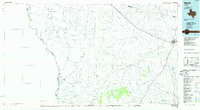
1985 Map of Marfa
USGS Topo · Published 1985About this map
The high desert plateau around Marfa is defined by a vast network of ephemeral draws and rugged mountain ranges in the mid-1980s. The landscape transitions from the peaks of the Sierra Vieja and Cuesta Del Burro down to the Rio Grande at the United States-Mexico border. Along the river, small settlements like Candelaria and Pueblo Nuevo persist at the end of remote roads, while the regional hub of Marfa thrives at the junction of the Southern Pacific and Atchison Topeka and Santa Fe railroads. Evidence of the area's transit history and ranching economy is visible in features like the Stage Stand and the Loma Plata Mine. A series of arroyos, such as Arroyo Chupaderos and Arroyo Hot Springs, carve through the western slopes, illustrating the complex drainage patterns of this arid borderland region.
Find a feature on this map
76 named features on this map. Tap any name to fly to it.
Don’t see what you’re looking for? This feature index may not catch every label — zoom into the map to look around manually.
Map Details
Editions of this 1985 Marfa Map
2 editions found
Other maps of this area

1892 · Chispa
USGS Topo · 1:125,000

1894 · Valentine
USGS Topo · 1:125,000

1894 · Fort Davis
USGS Topo · 1:125,000

1895 · Chispa
USGS Topo · 1:125,000

1895 · Marfa
USGS Topo · 1:125,000

1895 · Alpine
USGS Topo · 1:125,000

1896 · Ruidosa
USGS Topo · 1:125,000

1896 · San Carlos
USGS Topo · 1:125,000

1896 · Shafter
USGS Topo · 1:125,000

1897 · Valentine
USGS Topo · 1:125,000