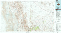
1985 Map of Marfa
USGS Topo · Published 1993About this map
Marfa sits at the eastern edge of a high-desert landscape where the Southern Pacific railroad cuts across the expansive Ryan Flat. This mid-1980s compilation documents the international border along the Rio Grande, showing the riverside settlements of Candelaria and Pueblo Nuevo. The terrain transitions from the open flats into the dramatic elevations of the Sierra Vieja and the Cuesta Del Burro, with Capote Peak serving as a prominent landmark. Numerous arroyos and draws, including Arroyo Sanguijuela and Wild Horse Draw, illustrate the complex drainage patterns that define this part of West Texas. Regional infrastructure is represented by the Municipal Airport and a network of highways like 17 and 67 that connect the isolated ranching communities and small outposts like Aragon to the larger county seat.
Find a feature on this map
56 named features on this map. Tap any name to fly to it.
Don’t see what you’re looking for? This feature index may not catch every label — zoom into the map to look around manually.
Map Details
Editions of this 1985 Marfa Map
2 editions found
Other maps of this area

1892 · Chispa
USGS Topo · 1:125,000

1894 · Valentine
USGS Topo · 1:125,000

1894 · Fort Davis
USGS Topo · 1:125,000

1895 · Chispa
USGS Topo · 1:125,000

1895 · Marfa
USGS Topo · 1:125,000

1895 · Alpine
USGS Topo · 1:125,000

1896 · Ruidosa
USGS Topo · 1:125,000

1896 · San Carlos
USGS Topo · 1:125,000

1896 · Shafter
USGS Topo · 1:125,000

1897 · Valentine
USGS Topo · 1:125,000