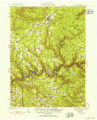
1936 Map of Marienville
USGS Topo · Published 1953About this map
Marienville serves as a central hub in this mid-1930s landscape, where the Baltimore and Ohio RR cuts through the timbered highlands of the Allegheny plateau. The topography is defined by the winding course of the Clarion River, which carves a deep valley through Barnett and Millstone townships. The map documents a rural infrastructure of small schoolhouses like Fitzgerald Sch and Shippen Sch and the spiritual life of communities at Sigel Ch and Greenwood Ch. Evidence of state and federal conservation efforts is visible through multiple fire lookouts, including the Muzette Fire Tower and Hemlock Fire Tower, alongside several CCC Camp locations. This era represents a period of regrowth for the Pennsylvania wilds, balancing industrial remnants like the Crawford Pump Sta with emerging recreational sites such as Loleta Camp Ground.
Find a feature on this map
88 named features on this map. Tap any name to fly to it.
Don’t see what you’re looking for? This feature index may not catch every label — zoom into the map to look around manually.
Map Details
Editions of this 1936 Marienville Map
3 editions found

Other maps of this area

1906 · Clarion
USGS Topo · 1:62,500

1907 · Clarion
USGS Topo · 1:62,500

1918 · Loleta
USGS Topo · 1:62,500

1922 · Tionesta
USGS Topo · 1:62,500

1922 · Du Bois
USGS Topo · 1:62,500

1924 · Du Bois
USGS Topo · 1:62,500

1924 · Tionesta
USGS Topo · 1:62,500

1924 · Brookville
USGS Topo · 1:62,500

1926 · Brookville
USGS Topo · 1:62,500

1927 · Tidioute
USGS Topo · 1:48,000