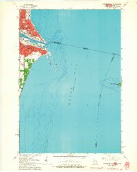
1963 Map of Marinette East
USGS Topo · Published 1964About this map
The border cities of Menominee, Michigan, and Marinette, Wisconsin, face one another across the mouth of the Menominee River in this 1960s survey. The map details a dense urban and industrial shoreline where the river meets Green Bay, featuring numerous municipal landmarks such as the Courthouse, Post Office, and several schools including Lincoln Sch and St Ann Sch. Transport networks are prominently shown, with both the C & N W and C M St P & P railroads serving the waterfront districts. Further offshore, the map transitions into the waters of the bay, marking the shifting sands of Seagull Bar and the isolated Green Island to the east. This period of development shows the cities as established industrial hubs, with clearly defined residential blocks and public spaces like Red Arrow Park and Lauerman Field.
Find a feature on this map
54 named features on this map. Tap any name to fly to it.
Don’t see what you’re looking for? This feature index may not catch every label — zoom into the map to look around manually.
Map Details
Editions of this 1963 Marinette East Map
2 editions found
Other maps of this area

1939 · Marinette
USGS Topo · 1:48,000

1954 · Escanaba
USGS Topo · 1:250,000

1954 · Manitowoc
USGS Topo · 1:250,000

1957 · Escanaba
USGS Topo · 1:250,000

1958 · Escanaba
USGS Topo · 1:250,000

1958 · Manitowoc
USGS Topo · 1:250,000

1960 · Sturgeon Bay
USGS Topo · 1:62,500

1961 · Little Sturgeon
USGS Topo · 1:62,500

1961 · Chambers Island
USGS Topo · 1:62,500
1963 · Marinette West
USGS Topo · 1:24,000