
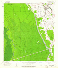
1953 Map of Maringouin
USGS Topo · Published 1954About this map
Maringouin and the neighboring settlement of Musson occupy the narrow, fertile natural levees between Bayou Grosse Tete and Bayou Maringouin. In this mid-century landscape, the transition from organized agriculture to the dense bottomland of the Atchafalaya Floodway is sudden and stark. The eastern edge is defined by the East Protection Levee, a massive engineering work separating the town's small-plot farms from a wilderness of bayous like Bayou Button and Bayou Des Glaises.
Find a feature on this map
34 named features on this map. Tap any name to fly to it.
Don’t see what you’re looking for? This feature index may not catch every label — zoom into the map to look around manually.
Map Details
Editions of this 1953 Maringouin Map
2 editions found
Other maps of this area

1906 · Bayou Sara
USGS Topo · 1:125,000

1935 · Osca Bayou
USGS Topo · 1:62,500

1939 · Fordoche
USGS Topo · 1:62,500

1940 · Grosse Tete
USGS Topo · 1:62,500

1953 · Cow Bayou
USGS Topo · 1:24,000

1953 · Grosse Tete SW
USGS Topo · 1:24,000

1954 · Fordoche
USGS Topo · 1:24,000

1954 · Erwinville
USGS Topo · 1:24,000

1954 · Grosse Tete
USGS Topo · 1:24,000

1954 · Baton Rouge
USGS Topo · 1:250,000