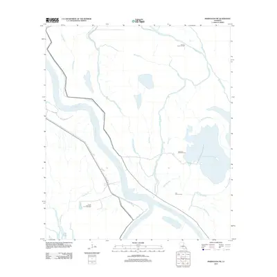
2012 Map of Maringouin NW
USGS Topo · Published 2012About this map
The Atchafalaya River corridor defines this portion of the Louisiana basin, where complex hydraulic engineering and industrial extraction intersect. By the early 21st century, the landscape is a patchwork of natural bayous and human-altered channels, most notably the Whisky Bay Pilot Channel and the Little Alabama Bayou. The prevalence of energy extraction is clear through numerous designated zones like the Happytown Oil and Gas Field and the Lake Valerie Oil Field. Transportation into these swampy reaches is limited to specialized routes such as W Atchafalaya Rd and the Dixie Ramp, which provide access to the river's edge. Notable water bodies such as Lake Bigeux and Bayou des Ourses remain as traditional landmarks in a region dominated by the ebb and flow of the Atchafalaya's distributaries.
Find a feature on this map
22 named features on this map. Tap any name to fly to it.
Don’t see what you’re looking for? This feature index may not catch every label — zoom into the map to look around manually.
Map Details
Editions of this 2012 Maringouin NW Map
This is the sole edition of this map. No revisions or reprints were ever made.
Other maps of this area

1935 · Osca Bayou
USGS Topo · 1:62,500

1939 · Fordoche
USGS Topo · 1:62,500

1940 · Arnaudville
USGS Topo · 1:62,500

1953 · Cow Bayou
USGS Topo · 1:24,000

1953 · Maringouin
USGS Topo · 1:24,000

1954 · Fordoche
USGS Topo · 1:24,000

1954 · Baton Rouge
USGS Topo · 1:250,000

1955 · Osca Bayou
USGS Topo · 1:62,500

1955 · Fordoche
USGS Topo · 1:62,500

1956 · Baton Rouge
USGS Topo · 1:250,000
Featured Places
- St. Landry Parish, LA
- Saint Martin Parish, LA
- Iberville Parish, LA
- Pointe Coupee Parish, LA
- United States