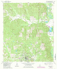
1979 Map of Marion North
USGS Topo · Published 1986About this map
Marion serves as the focal point for this late-1970s topographic study, showcasing the layout of the city and its educational landmark, Judson College. The landscape is defined by the winding course of the Cahaba River to the east and the protected timberlands of the Talladega National Forest. A notable concentration of rural infrastructure is visible northeast of the town, including the Marion National Fish Hatchery and its associated ponds.
Find a feature on this map
31 named features on this map. Tap any name to fly to it.
Don’t see what you’re looking for? This feature index may not catch every label — zoom into the map to look around manually.
Map Details
Editions of this 1979 Marion North Map
2 editions found
Other maps of this area

1953 · Montgomery
USGS Topo · 1:250,000

1956 · Montgomery
USGS Topo · 1:250,000

1957 · Montgomery
USGS Topo · 1:250,000

1959 · Summerfield
USGS Topo · 1:62,500

1975 · Summerfield SW
USGS Topo · 1:24,000

1979 · Marion North
USGS Topo · 1:24,000

1979 · Scott Station
USGS Topo · 1:24,000

1979 · Morgan Springs
USGS Topo · 1:24,000

1979 · Marion South
USGS Topo · 1:24,000

1979 · Harrisburg
USGS Topo · 1:24,000