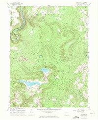
1968 Map of Markleton
USGS Topo · Published 1972About this map
Mount Davis anchors this Pennsylvania survey, standing as a prominent high point within the Forbes State Forest during the late 1960s. The landscape is defined by the winding course of the Casselman River, which carves through the terrain alongside the parallel tracks of the Baltimore and Ohio and Western Maryland railroads. These transit corridors served the small settlements of Markleton and Pinkerton, the latter notable for the Pinkerton Tunnel bypassing a sharp river bend.
Find a feature on this map
48 named features on this map. Tap any name to fly to it.
Don’t see what you’re looking for? This feature index may not catch every label — zoom into the map to look around manually.
Map Details
Editions of this 1968 Markleton Map
2 editions found
Other maps of this area

1899 · Grantsville
USGS Topo · 1:62,500

1900 · Accident
USGS Topo · 1:62,500

1904 · Grantsville
USGS Topo · 1:62,500

1921 · Meyersdale
USGS Topo · 1:62,500

1922 · Confluence
USGS Topo · 1:62,500

1931 · Confluence
USGS Topo · 1:62,500

1933 · Confluence
USGS Topo · 1:62,500

1939 · Meyersdale
USGS Topo · 1:62,500

1944 · Meyersdale
USGS Topo · 1:62,500

1946 · Grantsville
USGS Topo · 1:24,000
Featured Places
- Black Township, PA
- Addison Township, PA
- Upper Turkeyfoot Township, PA
- Elk Lick Township, PA
- Markleton, Black Township