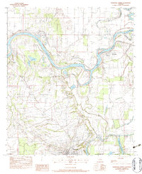
1983 Map of Marksville North
USGS Topo · Published 1983About this map
The Red River meanders through the heart of the central Louisiana lowlands, carving a complex path of oxbows and cutoffs between Catahoula Parish and Avoyelles Parish. The landscape is defined by the Prairie des Avoyelles, where small agrarian settlements like Vick, Moncla, and Brouillette are anchored by local landmarks such as Vick Ch and St Genevieve Ch. To the south, the city of Marksville sits at the edge of a dense hydrological network including the Petite Riviere and Bayou Bourbeux.
Find a feature on this map
32 named features on this map. Tap any name to fly to it.
Don’t see what you’re looking for? This feature index may not catch every label — zoom into the map to look around manually.
Map Details
Editions of this 1983 Marksville North Map
3 editions found
Other maps of this area

1935 · Tooleys
USGS Topo · 1:62,500

1940 · Marksville
USGS Topo · 1:62,500

1941 · Voorhies
USGS Topo · 1:62,500

1941 · Buckeye
USGS Topo · 1:62,500

1941 · Tooleys
USGS Topo · 1:62,500

1953 · Alexandria
USGS Topo · 1:250,000

1953 · Natchez
USGS Topo · 1:250,000

1955 · Alexandria
USGS Topo · 1:250,000

1956 · Natchez
USGS Topo · 1:250,000

1959 · Natchez
USGS Topo · 1:250,000