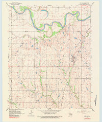
1968 Map of Marland
USGS Topo · Published 1984About this map
The Salt Fork Arkansas River carves a dramatic serpentine path across this north-central Oklahoma landscape, creating prominent meanders such as Horseshoe Lake. In the late 1960s, the region was defined by a mix of agricultural terrain and active energy extraction, evidenced by the Sands Oil Field and the South Ceres Oil Field. The small town of Marland serves as the primary settlement, situated along the Atchison Topeka and Santa Fe railroad line.
Find a feature on this map
24 named features on this map. Tap any name to fly to it.
Don’t see what you’re looking for? This feature index may not catch every label — zoom into the map to look around manually.
Map Details
Editions of this 1968 Marland Map
2 editions found
Other maps of this area

1955 · Enid
USGS Topo · 1:250,000

1958 · Enid
USGS Topo · 1:250,000

1968 · Tonkawa SE
USGS Topo · 1:24,000

1968 · Marland
USGS Topo · 1:24,000

1968 · Ponca City NW
USGS Topo · 1:24,000

1968 · Ponca City SE
USGS Topo · 1:24,000

1968 · Tonkawa
USGS Topo · 1:24,000
1968 · Ponca City
USGS Topo · 1:24,000

1972 · Morrison NE
USGS Topo · 1:24,000

1972 · Red Rock
USGS Topo · 1:24,000