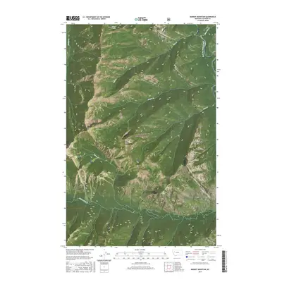
2017 Map of Marmot Mountain
USGS Topo · Published 2017About this map
The Flathead National Forest defines this high-elevation landscape in the late 2010s, characterized by steep ridgelines and the significant drainage system of the South Fork Flathead River. The topography is dominated by prominent summits such as Marmot Mtn and Snow Peak, which serve as the primary landmarks in this roadless wilderness. The map reveals an intricate network of waterways, including Little Salmon Cr and Hungry Cr, which carve through the terrain. Evidence of glacial and geological forces is visible in features like Picture Lake and the precipitous Slick Rock. This survey provides a precise accounting of the Public Land Survey System grid, demarcating townships like t23n r14w and several numbered parcels, such as PB 40 and PB 45, within the protected forest boundaries.
Find a feature on this map
25 named features on this map. Tap any name to fly to it.
Don’t see what you’re looking for? This feature index may not catch every label — zoom into the map to look around manually.
Map Details
Editions of this 2017 Marmot Mountain Map
This is the sole edition of this map. No revisions or reprints were ever made.
Other maps of this area

1936 · Silvertip
USGS Topo · 1:96,000

1942 · Silvertip
USGS Topo · 1:125,000

1955 · Choteau
USGS Topo · 1:250,000

1957 · Choteau
USGS Topo · 1:250,000

1958 · Choteau
USGS Topo · 1:250,000

1962 · Choteau
USGS Topo · 1:250,000

1965 · Sunburst Lake
USGS Topo · 1:24,000
1965 · String Creek
USGS Topo · 1:24,000
1965 · Holland Peak
USGS Topo · 1:24,000

1970 · Big Salmon Lake East
USGS Topo · 1:24,000