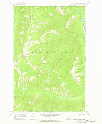
1970 Map of Marmot Mountain
USGS Topo · Published 1973About this map
The Bob Marshall Wilderness and Flathead National Forest dominate this 1970 survey, revealing a landscape defined by dramatic elevation changes and a dense network of watercourses. The eastern boundary is marked by the South Fork Flathead River, which serves as the primary drainage for numerous tributaries like Hungry Creek and Snow Creek. The terrain is punctuated by high summits including Marmot Mountain, Stadium Peak, and Snow Peak, with the notable Picture Ridge running through the northwestern sector.
Find a feature on this map
19 named features on this map. Tap any name to fly to it.
Don’t see what you’re looking for? This feature index may not catch every label — zoom into the map to look around manually.
Map Details
Editions of this 1970 Marmot Mountain Map
This is the sole edition of this map. No revisions or reprints were ever made.
Other maps of this area

1936 · Silvertip
USGS Topo · 1:96,000

1942 · Silvertip
USGS Topo · 1:125,000

1955 · Choteau
USGS Topo · 1:250,000

1957 · Choteau
USGS Topo · 1:250,000

1958 · Choteau
USGS Topo · 1:250,000

1962 · Choteau
USGS Topo · 1:250,000

1965 · Sunburst Lake
USGS Topo · 1:24,000
1965 · String Creek
USGS Topo · 1:24,000
1965 · Holland Peak
USGS Topo · 1:24,000

1970 · Big Salmon Lake East
USGS Topo · 1:24,000