
1960 Map of Marsh Coulee
USGS Topo · Published 1962About this map
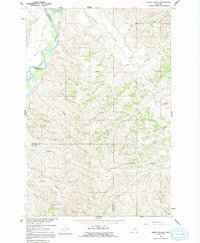
The Yellowstone River cuts through the northwest corner of this 1960 landscape, defining the edge of the Big Ox Bottom. This reach of the river valley is framed by a dense network of coulees and creeks that drain the high ground between Treasure and Big Horn counties. The map captures a rural ranching environment where life centered around water sources like Tullock Creek and the localized Tullock Creek Sch. Numerous family-named or descriptive landmarks such as Greene Coulee, Eckman Coulee, and the intriguing Fountain of Youth suggest the early settlement history of this Montana drainage. Much of the interior is accessible only by a system of Jeep Trails, illustrating the isolation of these breaks above the river valley during the mid-century period.
Find a feature on this map
21 named features on this map. Tap any name to fly to it.
Don’t see what you’re looking for? This feature index may not catch every label — zoom into the map to look around manually.
Map Details
Editions of this 1960 Marsh Coulee Map
2 editions found
Other maps of this area

1894 · Fort Custer
USGS Topo · 1:125,000

1954 · Hardin
USGS Topo · 1:250,000

1954 · Forsyth
USGS Topo · 1:250,000

1957 · Hardin
USGS Topo · 1:250,000

1957 · Forsyth
USGS Topo · 1:250,000

1958 · Forsyth
USGS Topo · 1:250,000

1958 · Hardin
USGS Topo · 1:250,000

1960 · Bighorn
USGS Topo · 1:24,000

1960 · Foster
USGS Topo · 1:24,000

1960 · Custer
USGS Topo · 1:24,000