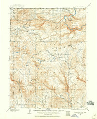
1906 Map of Marsh Peak
USGS Topo · Published 1960About this map
Ashley National Forest covers much of this high mountain landscape, which was surveyed by E. M. Douglas and A. E. Murlin in the first decade of the twentieth century. The map centers on the high-elevation divide of the Uinta Meridian, where snowmelt feeds systems like Carter Creek and Whiterocks Creek. This era reveals a localized industrial economy tied to the timber and mineral resources of the peaks, evidenced by several scattered timber operations such as Griffin's Mill, Johnsons Mill, and Flume Mill.
Find a feature on this map
65 named features on this map. Tap any name to fly to it.
Don’t see what you’re looking for? This feature index may not catch every label — zoom into the map to look around manually.
Map Details
Editions of this 1906 Marsh Peak Map
2 editions found
Other maps of this area

1885 · Ashley
USGS Topo · 1:250,000

1885 · Uinta
USGS Topo · 1:250,000

1905 · Gilbert Peak
USGS Topo · 1:125,000

1906 · Gilbert Peak
USGS Topo · 1:125,000

1906 · Marsh Peak
USGS Topo · 1:125,000

1907 · Jensen
USGS Topo · 1:125,000

1908 · Marsh Peak
USGS Topo · 1:125,000

1910 · Jensen
USGS Topo · 1:125,000

1917 · Vernal
USGS Topo · 1:125,000

1939 · Duchesne
USGS Topo · 1:125,000