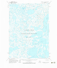
1954 Map of Marshall A-6
USGS Topo · Published 1983About this map
The vast, water-heavy landscape of the Clarence Rhode National Wildlife Range Area No 1 dominates this mid-century topographic survey. A saturated wetland environment, the region is defined by an intricate network of countless unnamed small lakes and ponds that stretch across the Yukon-Kuskokwim Delta. On the eastern edge of the sheet, the significant expanse of Aropuk Lake stands out as a primary geographic landmark. The topography, mapped by the Army Map Service using aerial photography from the early 1950s, reveals a terrain where land and water are inextricably linked, characterized by an Indefinite Boundary that reflects the shifting nature of these coastal lowlands. This survey documents the area before significant modern changes, providing a clear record of the hydrography in one of Alaska’s most remote wildlife habitats.
Find a feature on this map
3 named features on this map. Tap any name to fly to it.
Don’t see what you’re looking for? This feature index may not catch every label — zoom into the map to look around manually.
Map Details
Editions of this 1954 Marshall A-6 Map
2 editions found
Other maps of this area

1951 · Marshall
USGS Topo · 1:250,000

1951 · Baird Inlet
USGS Topo · 1:250,000
1953 · Marshall A-5
USGS Topo · 1:63,360

1953 · Marshall B-6
USGS Topo · 1:63,360

1953 · Marshall B-7
USGS Topo · 1:63,360

1953 · Marshall B-5
USGS Topo · 1:63,360

1953 · Baird Inlet D-5
USGS Topo · 1:63,360

1954 · Baird Inlet D-6
USGS Topo · 1:63,360

1954 · Marshall A-6
USGS Topo · 1:63,360
1954 · Marshall A-7
USGS Topo · 1:63,360