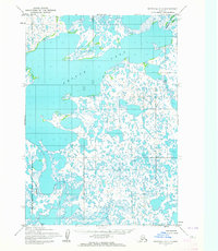
1953 Map of Marshall A-5
USGS Topo · Published 1964About this map
Aropuk Lake dominates this 1950s landscape, a massive expanse of water surrounded by an intricate web of smaller ponds and marshy lowlands in the Yukon-Kuskokwim Delta. This map represents the region just as the Clarence Rhode National Wildlife Range was established to protect the critical nesting grounds of migratory birds. Within this refuge lies Area No 1, highlighting early federal conservation efforts in the Alaska Territory. The terrain is defined by a lack of permanent human settlements or roads, instead showing the natural hydrology of the tundra where features like Tukliknek connect the sprawling aquatic systems. Mapped by the Army Map Service using photogrammetric methods from 1951 aerial photography, the sheet records a frozen-in-time view of an untouched wilderness prior to later environmental shifts and modern development.
Find a feature on this map
9 named features on this map. Tap any name to fly to it.
Don’t see what you’re looking for? This feature index may not catch every label — zoom into the map to look around manually.
Map Details
Editions of this 1953 Marshall A-5 Map
3 editions found
Other maps of this area

1951 · Marshall
USGS Topo · 1:250,000

1951 · Baird Inlet
USGS Topo · 1:250,000

1953 · Marshall B-6
USGS Topo · 1:63,360

1953 · Marshall B-5
USGS Topo · 1:63,360

1953 · Baird Inlet D-5
USGS Topo · 1:63,360

1954 · Baird Inlet D-6
USGS Topo · 1:63,360

1954 · Marshall B-4
USGS Topo · 1:63,360

1954 · Marshall A-6
USGS Topo · 1:63,360
1954 · Marshall A-4
USGS Topo · 1:63,360

1954 · Marshall
USGS Topo · 1:250,000