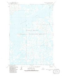
1953 Map of Marshall A-5
USGS Topo · Published 1991About this map
Yukon Delta National Wildlife Refuge dominates this mid-century landscape, capturing a vast expanse of the Alaskan tundra as it appeared during 1953 field annotations. The environment is characterized by an intricate network of wetlands, small ponds, and the prominent Aropuk Lake, which spans the northern half of the sheet. The hydrological character of the region is further defined by the Izaviknek waterway in the northeast. This 1953 survey, derived from aerial photography taken by the Defense Mapping Agency in the early 1950s, provides a record of the delta’s shifting surface before modern ecological changes, showing a landscape devoid of permanent roads or established settlements.
Find a feature on this map
3 named features on this map. Tap any name to fly to it.
Don’t see what you’re looking for? This feature index may not catch every label — zoom into the map to look around manually.
Map Details
Editions of this 1953 Marshall A-5 Map
3 editions found
Other maps of this area

1951 · Marshall
USGS Topo · 1:250,000

1951 · Baird Inlet
USGS Topo · 1:250,000
1953 · Marshall A-5
USGS Topo · 1:63,360

1953 · Marshall B-6
USGS Topo · 1:63,360

1953 · Marshall B-5
USGS Topo · 1:63,360

1953 · Baird Inlet D-5
USGS Topo · 1:63,360

1954 · Baird Inlet D-6
USGS Topo · 1:63,360

1954 · Marshall B-4
USGS Topo · 1:63,360

1954 · Marshall A-6
USGS Topo · 1:63,360
1954 · Marshall A-4
USGS Topo · 1:63,360