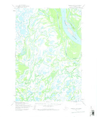
1952 Map of Marshall D-4
USGS Topo · Published 1973About this map
The Yukon River dominates the northeastern landscape of this territory, where the massive Goose Island splits the main channel. To the west, the land dissolves into an intricate network of waterways including the meandering Big River and Nantok River, illustrating the volatile nature of the Alaskan delta. This 1952 study, based on 1951 aerial photography, captures the region before extensive modern changes, marking the significant Driftwood Slough as a primary bypass for the Yukon's flow.
Find a feature on this map
13 named features on this map. Tap any name to fly to it.
Don’t see what you’re looking for? This feature index may not catch every label — zoom into the map to look around manually.
Map Details
Editions of this 1952 Marshall D-4 Map
2 editions found
Other maps of this area

1951 · Marshall
USGS Topo · 1:250,000

1952 · Kwiguk
USGS Topo · 1:250,000

1952 · Kwiguk A-4
USGS Topo · 1:63,360

1952 · Kwiguk A-3
USGS Topo · 1:63,360

1952 · Marshall D-5
USGS Topo · 1:63,360

1952 · Marshall D-4
USGS Topo · 1:63,360

1952 · Marshall C-5
USGS Topo · 1:63,360

1952 · Marshall D-3
USGS Topo · 1:63,360

1954 · Marshall C-3
USGS Topo · 1:63,360

1954 · Marshall C-4
USGS Topo · 1:63,360