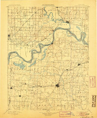
1901 Map of Marshall
USGS Topo · Published 1905About this map
The Missouri River and Grand River dictate the geography of this late nineteenth-century landscape, carving complex oxbows and islands through the fertile floodplains of Saline and Carroll counties. The convergence of these waterways near Brunswick created a dynamic environment where shifting river channels left behind features like Backbone Lake and Grand Pass Lake. This period captures the height of the steam-era transit network, with the Santa Fe Railroad and Chicago and Alton Railroad cutting across the prairies to serve established hubs like Marshall and Slater. Smaller, river-oriented settlements such as Miami and DeWitt illustrate the transition from riverboat commerce to rail-driven growth. In the western reaches, the survey identifies numerous family-named branches like Shoalman Creek and Darr Branch, providing essential landmarks for genealogists tracing ancestral land tracts near Malta Bend and Carrollton.
Find a feature on this map
96 named features on this map. Tap any name to fly to it.
Don’t see what you’re looking for? This feature index may not catch every label — zoom into the map to look around manually.
Map Details
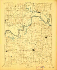
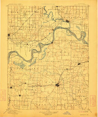
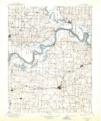
Editions of this 1901 Marshall Map
5 editions found

Other maps of this area

1885 · Warrensburg
USGS Topo · 1:125,000

1887 · Sedalia
USGS Topo · 1:125,000

1887 · Warrensburg
USGS Topo · 1:125,000

1888 · Boonville
USGS Topo · 1:125,000

1889 · Lexington
USGS Topo · 1:125,000

1890 · Glasgow
USGS Topo · 1:125,000

1890 · Marshall
USGS Topo · 1:125,000

1892 · Marshall
USGS Topo · 1:125,000

1894 · Sedalia
USGS Topo · 1:125,000

1894 · Warrensburg
USGS Topo · 1:125,000