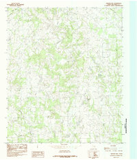
1984 Map of Martins Mill
USGS Topo · Published 1984About this map
Martins Mill serves as the central hub of this East Texas landscape, recorded during a 1978 field check. The settlement pattern here is defined by small clearings and homesteads connected by a winding network of rural roads, set against the dense woodland of Van Zandt County. The drainage system is particularly intricate, with the northward-flowing Kickapoo Creek joined by numerous local tributaries like Sand Branch and Diffy Creek. To the east, Holly Springs sits near the headwaters of Cream Level Creek, while the southern reaches are marked by Alligator Creek and Steve Creek. This 1984 edition, produced from original manuscript drawings, reveals the agricultural and timber-driven character of the terrain before late-twentieth-century developments altered the rural fabric of the region.
Find a feature on this map
14 named features on this map. Tap any name to fly to it.
Don’t see what you’re looking for? This feature index may not catch every label — zoom into the map to look around manually.
Map Details
Editions of this 1984 Martins Mill Map
This is the sole edition of this map. No revisions or reprints were ever made.
Other maps of this area

1948 · Brownsboro
USGS Topo · 1:62,500

1948 · Martins Mill
USGS Topo · 1:62,500

1949 · Martins Mill
USGS Topo · 1:62,500

1949 · Brownsboro
USGS Topo · 1:62,500

1956 · Tyler
USGS Topo · 1:250,000

1959 · Van
USGS Topo · 1:24,000

1959 · Grand Saline
USGS Topo · 1:62,500

1962 · Myrtle Springs
USGS Topo · 1:24,000
1962 · Canton
USGS Topo · 1:24,000

1984 · Tyler
USGS Topo · 1:250,000