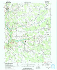
1993 Map of Marydel
USGS Topo · Published 1993About this map
The Delaware and Maryland border defines this 1990s landscape, where agricultural fields are intricately divided by an extensive network of drainage ditches such as Tappahanna Ditch and Culbreth Marsh Ditch. Local commerce and community life historically centered on rural hubs like Marydel, Sandtown, and Hazlettville. Evidence of early industry and milling is preserved at Choptank Mills near Mud Millpond, while numerous small congregations anchored the region at Thomas Chapel, Mt Moriah Church, and Mt Olivet Church. The southern portion of the quadrangle transitions into more natural terrain, featuring the Norman G Wilder State Wildlife Area and the headwaters of the Choptank River, highlighting the transition from managed farmland to the wetlands of the Black Swamp.
Find a feature on this map
83 named features on this map. Tap any name to fly to it.
Don’t see what you’re looking for? This feature index may not catch every label — zoom into the map to look around manually.
Map Details
Editions of this 1993 Marydel Map
This is the sole edition of this map. No revisions or reprints were ever made.
Other maps of this area

1899 · Dover
USGS Topo · 1:125,000

1905 · Denton
USGS Topo · 1:62,500

1905 · Barclay
USGS Topo · 1:62,500

1906 · Dover
USGS Topo · 1:125,000

1918 · Harrington
USGS Topo · 1:62,500

1920 · Dover
USGS Topo · 1:125,000

1926 · Wyoming
USGS Topo · 1:48,000

1930 · Wyoming
USGS Topo · 1:62,500

1931 · Wyoming
USGS Topo · 1:62,500

1944 · Denton
USGS Topo · 1:31,680