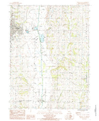
1985 Map of Maryville East
USGS Topo · Published 1985About this map
The eastern edge of Maryville dominates this 1980s landscape, where the urban grid gives way to the agricultural expanses of the White Cloud and Grant townships. The hydrology of the region is defined by the winding course of the One Hundred Two River, supported by an extensive system of levees and numerous tributaries like Mozingo Creek and Jones Branch.
Find a feature on this map
17 named features on this map. Tap any name to fly to it.
Don’t see what you’re looking for? This feature index may not catch every label — zoom into the map to look around manually.
Map Details
Editions of this 1985 Maryville East Map
This is the sole edition of this map. No revisions or reprints were ever made.
Other maps of this area

1925 · Stanberry
USGS Topo · 1:62,500

1927 · Bolckow
USGS Topo · 1:62,500

1939 · Stanberry
USGS Topo · 1:62,500

1940 · Parnell
USGS Topo · 1:62,500

1943 · Parnell
USGS Topo · 1:62,500

1943 · Maryville
USGS Topo · 1:62,500

1943 · Stanberry
USGS Topo · 1:62,500

1945 · Bolckow
USGS Topo · 1:62,500

1955 · Nebraska City
USGS Topo · 1:250,000

1957 · Nebraska City
USGS Topo · 1:250,000