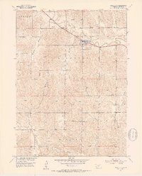
1951 Map of Mason City
USGS Topo · Published 1953About this map
Mason City (Mason Sta) serves as the primary hub of this Central Nebraska landscape, situated along the Chicago Burlington and Quincy railroad line. The map reveals a dense network of early 1950s rural infrastructure, where local life was organized around numerous small school districts and the geography of the creek valleys. Many of these institutions, such as Algernon Sch, Beechville Sch, and Happy Hollow Sch, are named for the townships and draws they served, providing a detailed look at the social distribution of Custer County before school consolidations.
Find a feature on this map
22 named features on this map. Tap any name to fly to it.
Don’t see what you’re looking for? This feature index may not catch every label — zoom into the map to look around manually.
Map Details
Editions of this 1951 Mason City Map
4 editions found
Other maps of this area

1951 · Ansley
USGS Topo · 1:24,000

1951 · Litchfield SW
USGS Topo · 1:24,000

1951 · Mason City SW
USGS Topo · 1:24,000

1951 · Mason City NW
USGS Topo · 1:24,000

1951 · Mason City
USGS Topo · 1:24,000

1951 · Ansley SE
USGS Topo · 1:24,000

1951 · Mason City SE
USGS Topo · 1:24,000

1951 · Arcadia SW
USGS Topo · 1:24,000

1951 · Litchfield
USGS Topo · 1:24,000

1955 · Broken Bow
USGS Topo · 1:250,000