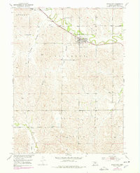
1951 Map of Mason City
USGS Topo · Published 1978About this map
Mason City serves as the primary rail hub on this mid-century Custer County survey, situated where the Burlington Northern line follows the valley of Mud Creek. The map documents a rural Nebraska landscape defined by its townships and water-carved terrain, including the distinctive Happy Hollow and Lazy Hollow. Local education and community life are anchored by the Algernon Sch and Mt Pleasant Sch, while a small Clay Pit suggests localized industrial activity near the railroad. The presence of a Cem and the transition from the settlement of Algernon to the broader rural precincts of Ansley and Elk Creek provide essential markers for genealogical research. Revisions from the 1970s layered onto the 1951 field check illustrate the persistence of these agrarian patterns and the critical role of the rail corridor in connecting these prairie communities.
Find a feature on this map
17 named features on this map. Tap any name to fly to it.
Don’t see what you’re looking for? This feature index may not catch every label — zoom into the map to look around manually.
Map Details
Editions of this 1951 Mason City Map
4 editions found
Other maps of this area

1951 · Ansley
USGS Topo · 1:24,000

1951 · Litchfield SW
USGS Topo · 1:24,000

1951 · Mason City SW
USGS Topo · 1:24,000

1951 · Mason City NW
USGS Topo · 1:24,000

1951 · Mason City
USGS Topo · 1:24,000

1951 · Ansley SE
USGS Topo · 1:24,000

1951 · Mason City SE
USGS Topo · 1:24,000

1951 · Arcadia SW
USGS Topo · 1:24,000

1951 · Litchfield
USGS Topo · 1:24,000

1955 · Broken Bow
USGS Topo · 1:250,000