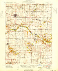
1949 Map of Mason City
USGS Topo · Published 1949About this map
Mason City serves as the primary hub of this Central Illinois landscape, where the Gulf Mobile and Ohio and Illinois Central railroads intersect. The terrain is defined by the winding course of Salt Creek, which is reinforced by a series of levees and crossed by the Hubly Bridge. This post-war survey illustrates a densely settled agricultural region, evidenced by the high frequency of rural institutions like Honey Heart Sch, Bee Grove Sch, and Irish Grove Ch. Significant industrial and genealogical markers appear throughout, including the Johnson Valley Mine and numerous family-named burial grounds like Richmond Grove Cem and Walnut Grove Cem. The presence of several distinct rail lines, including the Pennsylvania and Chicago and North Western, underscores the area's historical importance as a logistics corridor for the region's grain and coal.
Find a feature on this map
59 named features on this map. Tap any name to fly to it.
Don’t see what you’re looking for? This feature index may not catch every label — zoom into the map to look around manually.
Map Details
Editions of this 1949 Mason City Map
2 editions found

Other maps of this area

1907 · Springfield
USGS Topo · 1:62,500

1909 · Tallula
USGS Topo · 1:62,500

1911 · Lincoln
USGS Topo · 1:62,500

1913 · Lincoln
USGS Topo · 1:62,500

1929 · Manito
USGS Topo · 1:62,500

1930 · Springfield
USGS Topo · 1:62,500

1932 · Manito
USGS Topo · 1:62,500

1933 · Petersburg
USGS Topo · 1:62,500

1938 · Petersburg
USGS Topo · 1:62,500

1940 · Tallula
USGS Topo · 1:62,500