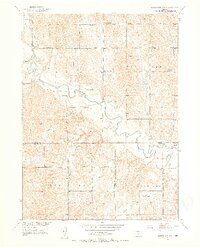
1951 Map of Mason City SW
USGS Topo · Published 1953About this map
South Loup River meanders through the heart of this central Nebraska landscape, defining a wide valley of Flat Bottom terrain where early agricultural life is marked by a network of rural schools. The map captures the meeting point of Custer, Dawson, and Buffalo counties, showing the modest settlement of Cumro in the northwest and the Milton Store further south. Education was clearly a focal point for the homesteading families of this era, as evidenced by several localized schoolhouses including Victory Hill Sch and Sunny Slope Sch. To the south, the headwaters of the Wood River and Wild Horse Creek begin to drain the loess hills, while Otter Valley provides a distinct geographical corridor. For family historians, the presence of the Box Elder Cem near the northern boundary provides a critical point of reference for the pioneering residents of the Custer County line.
Find a feature on this map
24 named features on this map. Tap any name to fly to it.
Don’t see what you’re looking for? This feature index may not catch every label — zoom into the map to look around manually.
Map Details
Editions of this 1951 Mason City SW Map
3 editions found
Other maps of this area

1896 · Lexington
USGS Topo · 1:125,000

1896 · Kearney
USGS Topo · 1:125,000

1899 · Lexington
USGS Topo · 1:125,000

1951 · Eddyville NE
USGS Topo · 1:24,000

1951 · Mason City SW
USGS Topo · 1:24,000

1951 · Eddyville
USGS Topo · 1:24,000

1951 · Mason City NW
USGS Topo · 1:24,000

1951 · Mason City
USGS Topo · 1:24,000

1951 · Mason City SE
USGS Topo · 1:24,000

1955 · Broken Bow
USGS Topo · 1:250,000