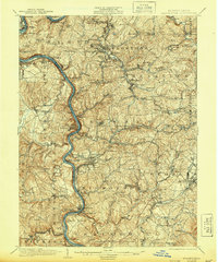
1935 Map of Masontown
USGS Topo · Published 1944About this map
The Monongahela River carves a deep valley through this industrial and agricultural landscape, serving as a primary corridor for transportation and extraction during the early twentieth century. Extensive river infrastructure, including Lock No 5 and Lock No 7, alongside historic crossings like Brown's Ferry and Crows Ferry, underscores the waterway's role in local commerce. The terrestrial landscape is defined by the National Road and the Pennsylvania Railroad, which connected coal-producing regions to wider markets. Industrial footprints are visible in coal-related labels such as Tower Hill No 2 and Continental No 1. Away from the river, the township structure of Luzerne, German, and Redstone is dotted with small-scale rural infrastructure, including the Mennonite Ch, Willow Grove Sch, and family-named landmarks like Griffin and Jacobs, reflecting the area's deep-rooted settlement patterns.
Find a feature on this map
163 named features on this map. Tap any name to fly to it.
Don’t see what you’re looking for? This feature index may not catch every label — zoom into the map to look around manually.
Map Details
Editions of this 1935 Masontown Map
2 editions found
Other maps of this area

1900 · Uniontown
USGS Topo · 1:62,500

1900 · Masontown
USGS Topo · 1:62,500

1901 · Amity
USGS Topo · 1:62,500

1901 · Waynesburg
USGS Topo · 1:62,500

1902 · Brownsville
USGS Topo · 1:62,500

1902 · Morgantown
USGS Topo · 1:62,500

1902 · Connellsville
USGS Topo · 1:62,500

1903 · Masontown
USGS Topo · 1:62,500

1904 · Amity
USGS Topo · 1:62,500

1904 · Bruceton
USGS Topo · 1:62,500