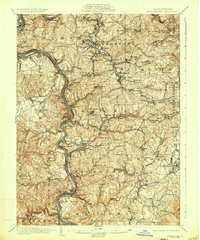
1935 Map of Masontown
USGS Topo · Published 1935About this map
The Monongahela River carves a deep valley through this southwestern Pennsylvania coal and coke region, serving as the primary corridor for industrial transport and settlement. Along its banks, company towns and landing sites like Crucible, Nemacolin, and Isabella reflect the intensive resource extraction of the early 20th century. Away from the river, the landscape is dotted with a dense network of country schools and churches, including the Mennonite Ch and Lutheran Ch, which anchored the rural communities of Nicholson and German townships.
Find a feature on this map
145 named features on this map. Tap any name to fly to it.
Don’t see what you’re looking for? This feature index may not catch every label — zoom into the map to look around manually.
Map Details
Editions of this 1935 Masontown Map
2 editions found
Other maps of this area

1900 · Uniontown
USGS Topo · 1:62,500

1900 · Masontown
USGS Topo · 1:62,500

1901 · Amity
USGS Topo · 1:62,500

1901 · Waynesburg
USGS Topo · 1:62,500

1902 · Brownsville
USGS Topo · 1:62,500

1902 · Morgantown
USGS Topo · 1:62,500

1902 · Connellsville
USGS Topo · 1:62,500

1903 · Masontown
USGS Topo · 1:62,500

1904 · Amity
USGS Topo · 1:62,500

1904 · Bruceton
USGS Topo · 1:62,500