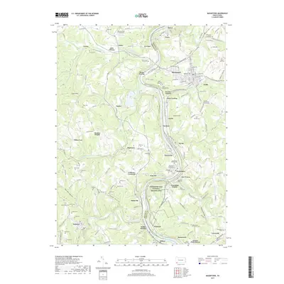
2019 Map of Masontown
USGS Topo · Published 2019About this map
The Monongahela River carves a deep valley through this Pennsylvania borderland, serving as the primary geographical and historical axis for the riverfront communities of Masontown, Greensboro, and Ronco. On the eastern bank, the Friendship Hill National Historic Site preserves the estate of statesman Albert Gallatin, reflecting the region's early political and architectural significance. The landscape is densely marked by the legacy of local families and religious congregations, with numerous family burial grounds like the Garrison Cem and Donham Cem scattered across the hills of Greene and Fayette counties. This 2019 survey documents the enduring settlement patterns in hamlets like Bobtown and Mapletown, where the topography is defined by prominent features such as Turkey Knob and Mundell Hollow. The river remains a central feature, designated here as the Upper Monongahela River Water Trail, connecting these coal-country settlements.
Find a feature on this map
145 named features on this map. Tap any name to fly to it.
Don’t see what you’re looking for? This feature index may not catch every label — zoom into the map to look around manually.
Map Details
Editions of this 2019 Masontown Map
This is the sole edition of this map. No revisions or reprints were ever made.
Other maps of this area

1900 · Masontown
USGS Topo · 1:62,500

1901 · Waynesburg
USGS Topo · 1:62,500

1902 · Morgantown
USGS Topo · 1:62,500

1903 · Masontown
USGS Topo · 1:62,500

1904 · Blacksville
USGS Topo · 1:62,500

1904 · Waynesburg
USGS Topo · 1:62,500

1923 · Blacksville
USGS Topo · 1:62,500

1925 · Blacksville
USGS Topo · 1:62,500

1925 · Morgantown
USGS Topo · 1:62,500

1931 · Masontown
USGS Topo · 1:62,500