
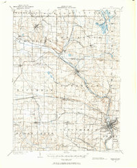
1901 Map of Massillon
USGS Topo · Published 1955About this map
The Tuscarawas River valley serves as a bustling corridor of transportation and heavy industry at the opening of the twentieth century. The Ohio and Erie Canal runs parallel to the river, winding through Canal Fulton and down toward Massillon, where it is joined by a complex web of railroads including the Pennsylvania System and the Baltimore and Ohio RR. This industrial landscape is further defined by extensive coal mining operations, evidenced by the Turkeyfoot Mine and Eureka Mine.
Find a feature on this map
78 named features on this map. Tap any name to fly to it.
Don’t see what you’re looking for? This feature index may not catch every label — zoom into the map to look around manually.
Map Details
Editions of this 1901 Massillon Map
2 editions found
Other maps of this area

1901 · Canton
USGS Topo · 1:62,500

1901 · Wooster
USGS Topo · 1:62,500

1903 · Massillon
USGS Topo · 1:62,500

1903 · Wooster
USGS Topo · 1:62,500

1903 · Canton
USGS Topo · 1:62,500

1903 · Akron
USGS Topo · 1:62,500

1904 · Medina
USGS Topo · 1:62,500

1905 · Akron
USGS Topo · 1:62,500

1906 · Medina
USGS Topo · 1:62,500

1906 · Kent
USGS Topo · 1:62,500