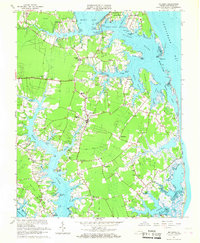
1965 Map of Mathews
USGS Topo · Published 1967About this map
Mathews stands as the central hub of this coastal Virginia landscape, surrounded by a complex network of necks and creeks leading into the Chesapeake Bay. The mid-1960s environment shows a community deeply tied to its waterfront, where Williams Wharf and the Public Landing near Onemo reflect a legacy of maritime commerce and recreation. Further north, Gwynn Island is separated from the mainland by The Narrows, while Crab Neck and Lilleys Neck define the jagged shoreline.
Find a feature on this map
99 named features on this map. Tap any name to fly to it.
Don’t see what you’re looking for? This feature index may not catch every label — zoom into the map to look around manually.
Map Details
Editions of this 1965 Mathews Map
3 editions found
Other maps of this area

1916 · Kilmarnock
USGS Topo · 1:48,000

1916 · Mathews
USGS Topo · 1:62,500

1917 · Kilmarnock
USGS Topo · 1:62,500

1917 · Mathews
USGS Topo · 1:62,500

1942 · Kilmarnock
USGS Topo · 1:62,500

1943 · Richmond
USGS Topo · 1:250,000

1948 · Ware Neck
USGS Topo · 1:24,000

1948 · Achilles
USGS Topo · 1:24,000

1948 · Deltaville
USGS Topo · 1:24,000

1948 · New Point Comfort
USGS Topo · 1:24,000