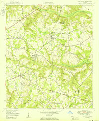
1950 Map of Matthews
USGS Topo · Published 1950About this map
Matthews and the surrounding Jefferson County landscape appear here just before the mid-century, defined by a dense network of rural churches and family-named landmarks. The map traces the winding course of Reedy Creek and Brushy Creek, which served as the lifeblood for early industry like Newton's Mill. The settlement pattern is anchored by small communities such as Stellaville and Zebina, where spiritual and educational life centered on institutions like the Thomason Spring Hill Church and School and Ways Grove Church.
Find a feature on this map
45 named features on this map. Tap any name to fly to it.
Don’t see what you’re looking for? This feature index may not catch every label — zoom into the map to look around manually.
Map Details
Editions of this 1950 Matthews Map
3 editions found

Other maps of this area

1919 · Gough
USGS Topo · 1:62,500

1920 · Stapleton
USGS Topo · 1:62,500

1922 · Harlem
USGS Topo · 1:62,500

1922 · Hephzibah
USGS Topo · 1:62,500

1948 · Hephzibah
USGS Topo · 1:62,500

1948 · Harlem
USGS Topo · 1:62,500

1948 · Stapleton
USGS Topo · 1:62,500

1948 · Gough
USGS Topo · 1:62,500

1948 · Blythe
USGS Topo · 1:24,000

1948 · Louisville
USGS Topo · 1:24,000