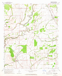
1967 Map of Mattson
USGS Topo · Published 1968About this map
The Big Sunflower River meanders through this portion of the Mississippi Delta, defining a landscape shaped by oxbow lakes and dense bayou networks during the late 1960s. Rural life in Coahoma County is anchored by small communities such as Mattson and Roundaway, connected by the Illinois Central railroad. The map reveals a deeply rooted social geography, evidenced by the high density of country churches and schools, including the Africa-Roundaway Sch, Harvey Chapel, and Sunshine Ch.
Find a feature on this map
49 named features on this map. Tap any name to fly to it.
Don’t see what you’re looking for? This feature index may not catch every label — zoom into the map to look around manually.
Map Details
Editions of this 1967 Mattson Map
2 editions found
Other maps of this area

1931 · Sumner
USGS Topo · 1:48,000

1931 · Drew
USGS Topo · 1:48,000

1932 · Tutwiler
USGS Topo · 1:48,000

1935 · Clarksdale
USGS Topo · 1:62,500

1935 · Sumner
USGS Topo · 1:62,500

1935 · Tutwiler
USGS Topo · 1:62,500

1935 · Mound Bayou
USGS Topo · 1:62,500

1939 · Sumner
USGS Topo · 1:62,500

1939 · Tutwiler
USGS Topo · 1:62,500

1939 · Clarksdale
USGS Topo · 1:62,500