1969 Map of Mayberry Spring
USGS Topo · Published 1972About this map
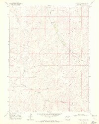
Bighole Gulch and Greasewood Gulch carve through this high-altitude landscape of Northwest Colorado during the late 1960s. The topography is defined by its water sources and ranching infrastructure, featuring named landmarks such as Kelly Spring, Mayberry Spring, and Clayton Spring. Evidence of human activity and utility development is sparse but significant, marked by a noted Corral and a Pipeline traversing the terrain. Surveyed at the end of the decade, the map records the locations of several Drill Holes, suggesting mineral or geological exploration in the region's remote basins. This survey captures a moment when the high desert of Moffat County remained largely open range, dominated by intermittent drainage systems and isolated springs essential for local cattle operations.
Find a feature on this map
9 named features on this map. Tap any name to fly to it.
Don’t see what you’re looking for? This feature index may not catch every label — zoom into the map to look around manually.
Map Details
Editions of this 1969 Mayberry Spring Map
2 editions found
Other maps of this area

1916 · Craig
USGS Topo · 1:125,000

1954 · Vernal
USGS Topo · 1:250,000

1954 · Craig
USGS Topo · 1:250,000

1957 · Craig
USGS Topo · 1:250,000

1958 · Vernal
USGS Topo · 1:250,000

1958 · Craig
USGS Topo · 1:250,000
1958 · Maybell
USGS Topo · 1:62,500

1960 · Craig
USGS Topo · 1:250,000

1960 · Vernal
USGS Topo · 1:250,000

1962 · Craig
USGS Topo · 1:250,000