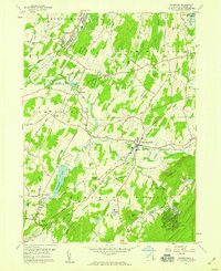
1957 Map of Maybrook
USGS Topo · Published 1959About this map
The village of Maybrook serves as a significant rail junction in the late 1950s, where the Erie RR and the New York New Haven and Hartford RR converge. This transport corridor shaped the surrounding Orange County landscape, linking settlements like Washingtonville and Burnside through a network of waterways including the Moodna Creek and Otter Kill. To the south, the terrain rises toward Schunemunk Mountain and Woodcock Hill, framing the agricultural and residential development of Blooming Grove.
Find a feature on this map
66 named features on this map. Tap any name to fly to it.
Don’t see what you’re looking for? This feature index may not catch every label — zoom into the map to look around manually.
Map Details
Editions of this 1957 Maybrook Map
4 editions found
Other maps of this area

1902 · Schunemunk
USGS Topo · 1:62,500

1903 · Newburg
USGS Topo · 1:62,500

1904 · Ellenville
USGS Topo · 1:62,500

1906 · Ellenville
USGS Topo · 1:62,500

1906 · Goshen
USGS Topo · 1:62,500

1908 · Goshen
USGS Topo · 1:62,500

1930 · Schunemunk
USGS Topo · 1:48,000

1935 · Schunemunk
USGS Topo · 1:62,500

1938 · Goshen
USGS Topo · 1:62,500

1942 · Goshen
USGS Topo · 1:24,000