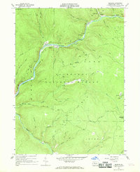
1966 Map of Mayburg
USGS Topo · Published 1969About this map
Tionesta Creek winds through a landscape defined by the remnants of the timber and rail era in this mid-1960s survey. Large portions of the territory are protected within the Allegheny National Forest, where the topography is incised by numerous waterways such as Salmon Creek and Minister Creek. A distinctive historical footprint is left by the Old Railroad Grade and Old RR Grade, which follow the creek banks and valley floors, tracing the old industrial routes that once connected the small forest settlements. Small hamlets and named locations like Mayburg, Balltown, and the evocatively named Seldom Seen Corners are scattered among the ridges. The presence of numerous oil and gas wells across the northern reaches indicates the continued extraction economy of the region, while the Tionesta Reservoir downstream suggests the transition toward water management and recreational use, further evidenced by the Minister Creek Recreation Area.
Find a feature on this map
45 named features on this map. Tap any name to fly to it.
Don’t see what you’re looking for? This feature index may not catch every label — zoom into the map to look around manually.
Map Details
Editions of this 1966 Mayburg Map
3 editions found
Other maps of this area

1918 · Loleta
USGS Topo · 1:62,500

1922 · Tionesta
USGS Topo · 1:62,500

1924 · Tionesta
USGS Topo · 1:62,500

1927 · Tidioute
USGS Topo · 1:48,000

1930 · Tidioute
USGS Topo · 1:62,500

1935 · Sheffield
USGS Topo · 1:48,000

1936 · Marienville
USGS Topo · 1:48,000

1941 · Sheffield
USGS Topo · 1:62,500

1941 · Marienville
USGS Topo · 1:62,500

1946 · Tionesta
USGS Topo · 1:62,500
Featured Places
- Balltown, Howe Township
- Howe Township, PA
- Truemans, Howe Township
- Jenks Township, PA
- Hickory Township, PA