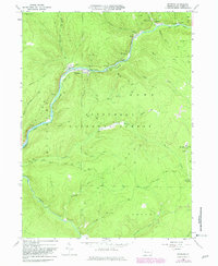
1966 Map of Mayburg
USGS Topo · Published 1982About this map
Tionesta Creek winds through the heart of the Allegheny National Forest, carving a deep valley that historically served as a corridor for industry and transit. By the mid-1960s, the landscape was a mix of conservation and resource extraction, characterized by numerous oil wells scattered across the drainages of Minister Creek and Salmon Creek. The infrastructure of a previous era remains visible through the Old Railroad Grade that follows the creek bank through Mayburg and Truemans. Small settlements like Minister and Porkey sit at the confluence of rugged runs, while newer developments like Tionesta Lake suggest the shift toward water management and recreation. This area, spanning the Howe and Jenks township lines, preserves the intricate network of forest roads and trails used by local woodsmen and oil workers, including the distinctively named Seldom Seen Corners.
Find a feature on this map
40 named features on this map. Tap any name to fly to it.
Don’t see what you’re looking for? This feature index may not catch every label — zoom into the map to look around manually.
Map Details
Editions of this 1966 Mayburg Map
3 editions found
Other maps of this area

1918 · Loleta
USGS Topo · 1:62,500

1922 · Tionesta
USGS Topo · 1:62,500

1924 · Tionesta
USGS Topo · 1:62,500

1927 · Tidioute
USGS Topo · 1:48,000

1930 · Tidioute
USGS Topo · 1:62,500

1935 · Sheffield
USGS Topo · 1:48,000

1936 · Marienville
USGS Topo · 1:48,000

1941 · Sheffield
USGS Topo · 1:62,500

1941 · Marienville
USGS Topo · 1:62,500

1946 · Tionesta
USGS Topo · 1:62,500
Featured Places
- Balltown, Howe Township
- Howe Township, PA
- Truemans, Howe Township
- Jenks Township, PA
- Hickory Township, PA