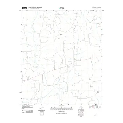
2010 Map of Maydelle
USGS Topo · Published 2010About this map
Maydelle and the surrounding pine-flecked hills of Cherokee County are documented here as they appeared at the start of the 2010s. The landscape is defined by its rural density, where narrow timber and county roads like Forestry Rd and Iron Bridge Creek Rd carve through the East Texas terrain. Local geography is anchored by Ghent Mountain and a network of waterways including Gum Creek and the curiously named One Arm Creek.
Find a feature on this map
56 named features on this map. Tap any name to fly to it.
Don’t see what you’re looking for? This feature index may not catch every label — zoom into the map to look around manually.
Map Details
Editions of this 2010 Maydelle Map
This is the sole edition of this map. No revisions or reprints were ever made.
Other maps of this area

1943 · Rusk
USGS Topo · 1:62,500

1945 · Rusk
USGS Topo · 1:62,500

1946 · Alto
USGS Topo · 1:62,500

1951 · Jacksonville
USGS Topo · 1:62,500

1952 · Slocum
USGS Topo · 1:62,500

1953 · Palestine
USGS Topo · 1:250,000

1957 · Palestine
USGS Topo · 1:250,000
1973 · Jacksonville East
USGS Topo · 1:24,000
1973 · Pryor Mountain
USGS Topo · 1:24,000
1973 · Rusk
USGS Topo · 1:24,000