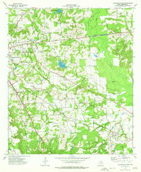
1973 Map of Jacksonville East
USGS Topo · Published 1976About this map
The eastern reaches of Jacksonville anchor this 1970s landscape, where the convergence of three major rail lines—the Southern Pacific, St Louis Southwestern, and Missouri Pacific—illustrates the region's historical importance as a shipping hub. Beyond the city center, the terrain is defined by a network of small agricultural and timber settlements such as Craft, Turney, and Gallatin. The map is particularly rich in genealogical data, preserving the locations of numerous family-named burial sites including Meador Cem, Staton Cem, and Tilley Cem. Land use patterns are further marked by a prominent Landing Strip and an Old Railroad Grade that speaks to changing transportation needs. Water features like Jacksonville Club Lake and Pine Crest Lake break up the wooded topography between the various branches of Mud Creek.
Find a feature on this map
42 named features on this map. Tap any name to fly to it.
Don’t see what you’re looking for? This feature index may not catch every label — zoom into the map to look around manually.
Map Details
Editions of this 1973 Jacksonville East Map
2 editions found
Other maps of this area

1937 · Troupe
USGS Topo · 1:48,000

1943 · Troup
USGS Topo · 1:62,500

1943 · Rusk
USGS Topo · 1:62,500

1945 · Rusk
USGS Topo · 1:62,500

1946 · Bullard
USGS Topo · 1:62,500

1948 · Bullard
USGS Topo · 1:62,500

1951 · Jacksonville
USGS Topo · 1:62,500

1953 · Palestine
USGS Topo · 1:250,000

1956 · Tyler
USGS Topo · 1:250,000

1957 · Palestine
USGS Topo · 1:250,000