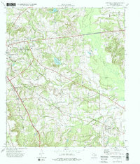
1973 Map of Jacksonville East
USGS Topo · Published 1976About this map
Jacksonville serves as the regional hub in this 1970s survey, anchoring a landscape defined by the intersection of three major rail lines. The Southern Pacific, Missouri Pacific RR, and St Louis Southwestern systems converge here, illustrating the town's role as a transportation nexus for Cherokee County. Beyond the urban center, the terrain transitions into a mosaic of small farming settlements and family landmarks. Genealogists will find significant value in the documentation of rural burial grounds such as Meador Cem, Tilley Cem, and Staton Cem, often located near crossroads or water features like Mud Creek. The presence of an Old Railroad Grade and the Old Turnpike near Turney provides a clear view of earlier transit corridors that predated the modern highway system, while scattered Oil Wells and a Gravel Pit indicate the local extractive economy.
Find a feature on this map
36 named features on this map. Tap any name to fly to it.
Don’t see what you’re looking for? This feature index may not catch every label — zoom into the map to look around manually.
Map Details
Editions of this 1973 Jacksonville East Map
2 editions found
Other maps of this area

1937 · Troupe
USGS Topo · 1:48,000

1943 · Troup
USGS Topo · 1:62,500

1943 · Rusk
USGS Topo · 1:62,500

1945 · Rusk
USGS Topo · 1:62,500

1946 · Bullard
USGS Topo · 1:62,500

1948 · Bullard
USGS Topo · 1:62,500

1951 · Jacksonville
USGS Topo · 1:62,500

1953 · Palestine
USGS Topo · 1:250,000

1956 · Tyler
USGS Topo · 1:250,000

1957 · Palestine
USGS Topo · 1:250,000